This last section of our exploration of the Camel from source to sea, has a distinctively different character as it opens out into the estuary before passing Padstow and entering the sea in Padstow Bay.
I will again put in the map by way of explanation.
In this last part, we go from Wadebridge to Padstow, with occasional deviations to the other shore of the estuary. This isn't an account of a single visit but draws from many over the past thirty years.
Re-joining the river and the Camel Trail which stopped on the south side of Wadebridge (see previous blog) we look back from the north side of the town as the Trail resumes. You can just discern the arches of the low town bridge over the river. Plenty of mud here at Low Water.
Looking downstream from the same place. The relatively new high-level bridge now by-passes the town on its way west.
It seems huge from underneath, as it strides across the saltmarsh below.
Just past the high level bridge. Careful scanning may well reveal Snipe crouching in the salt marsh.
Extensive areas of mud are exposed at low water giving winter feeding ground for a large variety of wading birds including flocks of hundreds of Golden Plovers.
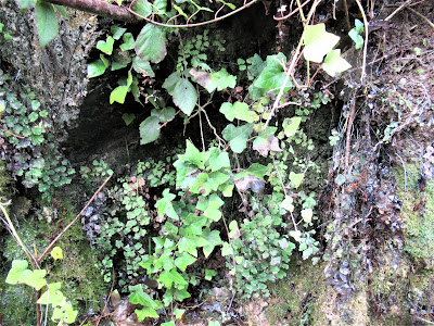
Maidenhair Fern, growing on Tufa, calcareous ooze which hardens in the air, is a substrate for this delicate fern. Usually established from gardens such as the abundant growth on the walls within the lime kilns at Cotehele Quay on the Tamar, it seems to be wild here and on a few cliffs on both north and south coasts in Cornwall.
Here it is growing in the first cutting made for the railway going out of Wadebridge. The Ivy protects it from the worst of the winter weather.
A party of birdwatchers looking across the mud towards Burniere on the opposite side. This is where the last main tributary enters the Camel, the River Amble. The excellent bird reserve on the Amble Marshes, Walmsley Sanctuary , discussed in a previous blog, runs up the shallow Amble valley behind Burniere.
This picture is taken from the hide at Burniere looking down the estuary at the areas of saltmarsh and mud flats pretty-well opposite the previous picture.
Going along the trail towards Padstow, high water gives a great expanse of water. Looking back to where we are coming from.
These are the spoil tips from quarries on the valley-side here. The stone was loaded onto boats at a jetty here, now long-disused. The well drained stony soils associated with this rubble give rise to a specialist flora of drought-tolerant plants including ferns such as Rusty-back.

The Trail goes over this bridge where Old Town Cove runs into the estuary. This is low water, showing the beautifully-constructed stonework on the banks supporting the bridge and embankment. Mullet will drift into the creek here at high water. This is one of the rare road access points on this side.
Cant Hill is a prominent landmark on the opposite bank.
The next, Little Petherick Creek , we meet as we go on towards Padstow is wider as the old railway and now the trail has to cross it by means of a substantial iron bridge.
Padstow, looking south. The Trail ends in the top left-hand corner.
Beyond Padstow on the far side is the dune area and popular holiday beach of Daymer Bay.
At some exceptionally low tides there are ancient beds of peat exposed at Daymer Bay. They are dated at 4400 years old.

With a small party of friends from the local Natural History Group in January 2015 we saw a number of sticks within these peat beds and also this length of tree trunk. This is a very vulnerable feature, liable to human damage as well as marine erosion.
The Camel reaches the sea beyond Padstow and the opposite holiday resort of Rock (reached by ferry)past the notorious Doom Bar, scene of many shipwrecks due to the ever-changing channel. A local brewery has named its popular Doom Bar Ale after this treacherous moving sand-bar.
And finally, past the headlands of Stepper Point and Pentire Head the river enters the sea.
Stepper Point.


No comments:
Post a Comment